
Ausangate Circuit hiking guide: route map, stages & where to stay
The Ausangate Circuit: a 66 km camping loop around Ausangate (6,384 m) in the Cusco region of Peru, from Tinki via Upis, the Pucacocha lakes, Palomani pass (5,200 m), Huchuy Finaya and Pacchanta. Most hikers take 5 days, 6 with Rainbow Mountain.
Best time to hike the Ausangate Circuit →

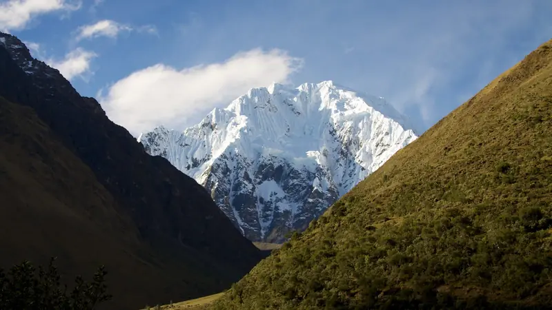
Photo: Petr Meissner, CC BY 2.0, cropped
The Ausangate Circuit is a high-altitude loop around Ausangate (6,384 m), the highest mountain of the Cordillera Vilcanota and the sacred apu of the Cusco region. It starts and ends in Tinki (also written Tinqui), a Quechua village about 3 hours by road east of Cusco, and crosses four passes between 4,850 m and about 5,200 m. On the way you pass turquoise glacial lakes, hanging glaciers, red and striped hillsides and herds of alpacas and llamas, and you sleep in your own tent at campsites used by local herding families. The usual walk is 5 days; take 6 if you add Vinicunca (Rainbow Mountain) or want shorter days.
The route
From Tinki the circuit heads south up the Upis valley to the campsite and hot springs below the north face of Ausangate. Day two climbs over Arapa pass (about 4,850 m) and drops to the red lakes of Pucacocha and Hatun Pucacocha. Day three is the hardest: over Apacheta pass (about 4,900 m) to Laguna Ausangatecocha at the foot of the glaciers, then up to Palomani pass, the high point of the trek at 5,165-5,200 m, and down to the herders' houses of Huchuy Finaya. Day four is long: up the open valley to Campa (Q'ampa) pass at about 5,050 m, past the Uturunku lakes and down to Pacchanta and its hot springs. The last day follows a dirt road gently down to Tinki.
This guide follows the circuit mapped on OpenStreetMap, anticlockwise from Tinki, and splits it into 5 stages of about 13.1 km each. The loop is about 66 km from the Tinki plaza. Many groups drive the first 10 km to the end of the dirt road below Upis, which shortens the first day to about 3 km.
Highlights
- The north face of Ausangate from Upis: glaciers above a green valley, with a hot pool to soak in at 4,400 m
- Pucacocha lakes: a chain of red, green and blue lakes below Arapa pass
- Laguna Ausangatecocha: a turquoise lake right under the hanging glaciers of the south face
- Palomani pass: the roof of the trek, with views of Ausangate's ice on one side and the coloured hills of Vinicunca on the other
- Uturunku (Otorongo) lakes and Pacchanta: a row of glacial lakes on the last high day, then hot springs in the village
- Vinicunca (Rainbow Mountain): an optional detour from the Pucacocha side over Warmisaya pass to the famous striped mountain, best reached before the day-trip crowds
When to walk the Ausangate Circuit
The dry season, May to September, is the main season, with clear mornings and stable weather. Nights are very cold: -10 °C or lower at camp in June and July, and water bottles freeze. April and October are quieter, with more cloud and the odd snow shower. From November to March it is the rainy season: daily rain and snow on the passes, slippery paths and fog. Snow can cover the passes in any month. Around late May or early June the Qoyllur Rit'i pilgrimage near Ocongate fills the buses from Cusco.
How many days do you need?
Most organised treks take 5 days and 4 nights, with the stage ends used here. Strong, well-acclimatised hikers can do it in 4 days; slower hikers and photographers take 6, splitting the long day four at a camp below Campa pass or adding the Rainbow Mountain detour. Plan at least 3 nights in Cusco (3,400 m) before you start, and ideally a lower trek or a day hike above 4,000 m.
Getting there and logistics
Tinki is on the Interoceanic Highway beyond Ocongate. Minibuses and colectivos leave Cusco early in the morning from the Paradero Livitaca area near the Coliseo Cerrado and take about 3 hours (S/15-20 in recent reports). Taxis in Tinki take you to the road end below Upis (about S/30-50 per car). At the end, a taxi or colectivo from Pacchanta saves the last road walk, and minibuses back to Cusco leave from the Tinki plaza; they thin out in the afternoon, so finish early.
There is no permit and no national booking system, and a guide is not compulsory, but most hikers go with an agency from Cusco that provides a guide, cook, tents and horses with an arriero (muleteer). Independent hikers can hire horses and an arriero in Tinki or Upis. The land belongs to Quechua communities, which charge several small tolls: expect S/10-20 at the entrance near Tinki or Upis, at Ausangatecocha and at Pacchanta, plus fees for some campsites and the hot springs. There is no official tariff, so carry small notes and ask for a ticket.
A lodge-to-lodge variant exists: the community tambos at Chillca, Machuraccay, Anantapata and Huampococha are sold only as a guided package that starts on the Pitumarca side and shares only part of this route.
Money, food and phone signal
Bring all the cash you need from Cusco in small notes; there is no reliable cash machine in Tinki and cards are not accepted on the trail. Tinki has small shops and simple restaurants, but buy your trek food in Cusco. Water is plentiful from streams and lakes, but alpacas and sheep graze everywhere, so filter or boil it. There is no mobile signal on most of the route, only short patches near Tinki, Pacchanta and on some high ground; carry a satellite messenger and an offline map, because the paths are often faint and unmarked.
What to pack
- A 4-season tent and a sleeping bag rated to -15 °C, plus an insulated mat
- Warm down jacket, hat, gloves and thermal layers for evenings below freezing
- Waterproof jacket and trousers, even in the dry season
- Sun hat, sunglasses and SPF 50 sunscreen: the UV is fierce above 4,500 m
- Water filter or tablets, stove and fuel (buy gas cartridges in Cusco)
- Trekking poles, which also help with guard dogs
- Altitude medicine on a doctor's advice, a first aid kit and a power bank
Difficulty
The Ausangate Circuit is a hard trek because of the altitude, not the terrain. The whole route is above 3,800 m, every camp is at 4,300-4,700 m and two passes are above 5,000 m. Day three crosses two passes and gains about 700 m; day four is about 21 km. Paths are mostly clear shepherd trails on grass and scree, with some steep loose slopes below Palomani. Altitude sickness is the main risk: if you have a severe headache, vomiting, confusion or breathlessness at rest, go down at once. Afternoon storms bring hail and lightning, so cross the passes in the morning.
Safety
In an emergency call 105 (police) or 106 (ambulance). Rescue in the Vilcanota is slow: there is no organised mountain rescue, ambulances can reach only Tinki and Pacchanta, and casualties are carried out by horse or by a helicopter that your insurer must arrange. In May 2026 a solo hiker went missing on the circuit, and the police now advise going with a registered agency. Never walk alone, leave your route with someone, and carry insurance that covers evacuation above 5,000 m. Herding families keep guard dogs; stay calm and use your poles.
Ausangate Circuit map
The whole Ausangate Circuit with its 5 stages, Tinki round Ausangate and back. Tap a stage on the map to open it. To follow the route with GPS and offline maps on the trail, open it in the free Outest app.
The 5 stages
The classic five-day camping loop round Ausangate from Tinki: up the Upis valley to the hot springs below the north face, over Arapa pass to the Pucacocha lakes, over Apacheta and Palomani, the high point at about 5,200 m, to Huchuy Finaya, over Campa pass to Pacchanta and back down to Tinki. Walking times allow for altitude above 4,300 m and faint shepherd paths. Each stage page has a map, elevation profile, the campsites and the nearest help.
| # | Stage | Distance | Level |
|---|---|---|---|
| 1 | Tinki → Upis | 13.1 km | hard |
| 2 | Upis → Pucacocha | 9.5 km | moderate |
| 3 | Pucacocha → Huchuy Finaya | 11.3 km | hard |
| 4 | Huchuy Finaya → Pacchanta | 20.7 km | hard |
| 5 | Pacchanta → Tinki | 11.0 km | moderate |
Emergency, hospitals and services
In an emergency call 105 (police) or 106 (SAMU ambulance). There is no organised mountain rescue in the Cordillera Vilcanota and almost no phone signal on the trail, so carry a satellite messenger and insurance that covers helicopter evacuation. Ambulances reach only Tinki and Pacchanta. 2 hospitals and health centres are within reach by road; the nearest doctor is in Ocongate and the hospitals with a 24-hour emergency department are in Cusco, about 3 hours away. Every stage page lists the nearest help.
Where to stay on the Ausangate Circuit
Campsites, a few village hostals in Tinki and Pacchanta and one community lodge, grouped by stage round Ausangate. Listings were checked online in October 2026. Places marked "not confirmed by the operator" are listed on OpenStreetMap or in hiker reports but could not be checked on an official page. Almost nothing on the circuit can be booked online: camp with your own tent, carry cash in soles for community and campsite fees, and arrange horses and an arriero in Tinki or through a Cusco agency.
Tinki (trailhead)
2 places
- 2 with rooms
Tinki
Tinki → Upis
3 places
- 2 with rooms
- 2 camping
Upis · Upis road
Upis → Pucacocha
3 places
- 3 camping
Hatun Pucacocha · Pucacocha
Pucacocha → Huchuy Finaya
3 places
- 1 with rooms
- 2 camping
- 1 with meals
Ausangatecocha · Huchuy Finaya · Machuraccay
Huchuy Finaya → Pacchanta
6 places
- 3 with rooms
- 3 camping
- 1 with meals
Huchuy Finaya · Otorongo lakes · Pacchanta
Pacchanta → Tinki
3 places
- 1 with rooms
- 1 with meals
Tinki
Plan your days
Pick any Ausangate Circuit stage in the free hike planner to see walking time, water to carry, calories, difficulty, the weather forecast and daylight.
More trail guides

Inca Trail
Peru · Cusco · 34 km · 4 stages
Salkantay Trek
Peru · Cusco · 65 km · 4 stages

Huayhuash Circuit
Peru · Áncash · 96 km · 9 stages

Santa Cruz Trek
Peru · Cordillera Blanca · 45 km · 4 stages

Choquequirao Trek
Peru · Apurímac and Cusco · 30 km · 3 stages

Tour du Mont Blanc
France · Italy · Switzerland · 166 km · 11 stages
Alta Via 1 · GR 20 · John Muir Trail · Laugavegur · Cotswold Way · Kerry Way · Camino Finisterre · West Highland Way · Walker's Haute Route · Kungsleden · Tour of Monte Rosa · Coast to Coast Walk · Pembrokeshire Coast Path · Hadrian's Wall Path · South Downs Way · Dingle Way · Wicklow Way · Fishermen's Trail · Camino Portugués · Alta Via 2 · Malerweg · Peaks of the Balkans · Overland Track · Lycian Way · St Paul Trail · Camino Francés · W Trek · Everest Base Camp Trek · Annapurna Circuit · Kumano Kodo Nakahechi · Camino del Norte · Via Francigena · GR10 · Pennine Way · Carian Trail · Evliya Çelebi Way · Kaçkar Mountains Traverse · Phrygian Way · Sultans Trail · Mount Ararat Climb · Hittite Trail · Troy Culture Route · Independence Way · Mysia Ways · Rheinsteig · Westweg · Goldsteig · GR54 Tour des Écrins · Via Alpina · Path of the Gods · Cinque Terre Trail · Alta Via 4 · GR221 Dry Stone Route · Stubai High Trail · Milford Track · Routeburn Track · Kepler Track · Tongariro Northern Circuit · Larapinta Trail · Great Ocean Walk · West Coast Trail · Wonderland Trail · Teton Crest Trail · Annapurna Base Camp Trek · Markha Valley Trek · Kilimanjaro Machame Route · Toubkal Circuit · Jordan Trail: Dana to Petra · Torres del Paine O Circuit · Abel Tasman Coast Track · Three Capes Track · Mestia to Ushguli Trek · Nakasendo Way · Berg Lake Trail · Skyline Trail (Jasper) · Fitz Roy & Cerro Torre Loop · Otter Trail · Fish River Canyon Hiking Trail · Camino Primitivo · Camino Inglés · Eagle Walk (Adlerweg) · Berliner Höhenweg · Cape Wrath Trail · Great Glen Way · Offa's Dyke Path · Cleveland Way · Rota Vicentina Historical Way · Via Podiensis (GR 65) · Heaphy Track · Queen Charlotte Track · Cape to Cape Track · Rockwall Trail · Juan de Fuca Marine Trail · Quilotoa Loop · Nahuel Huapi Traverse · Ala Kul Trek · Tiger Leaping Gorge High Trail · Mount Kenya Sirimon–Chogoria Traverse · Ghorepani Poon Hill Trek · Kilimanjaro Lemosho Route · Lebanon Mountain Trail · Aladağlar Traverse · Kokoda Track · Chilkoot Trail · Lost City Trek · GR R2 Réunion · M'Goun Traverse · Royal National Park Coast Track · Grand Cliff Top Walk · Snowies Alpine Walk · Rwenzori Central Circuit · Whale Trail · Thorsborne Trail · Paparoa Track · Mount Assiniboine Traverse · Sunshine Coast Trail · Sinai Trail · Rakiura Track · Grand Canyon Rim to Rim
Hike it with the route in your pocket
Outest has the Ausangate Circuit route offline, with elevation, water and village points, and a trail guide you can ask about stages, weather and where to sleep.