
Rockwall Trail hiking guide: route map, stages & where to stay
The Rockwall Trail in Kootenay National Park, British Columbia: about 54 km (34 miles) from the Paint Pots to Floe Lake below a 900 m limestone wall, over three alpine passes. Most hikers take 4–5 days, camping at five Parks Canada backcountry campgrounds booked in advance.
Best time to hike the Rockwall Trail →

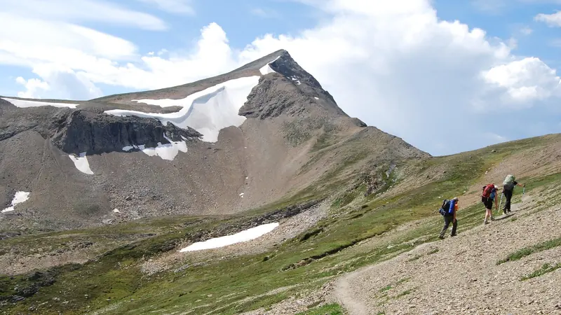
Photo: Benfwilliamson, CC BY-SA 4.0, cropped
The Rockwall Trail is the classic backpacking route of Kootenay National Park in the Canadian Rockies of British Columbia. It runs about 54 km along the foot of the Vermilion Range, a single wall of limestone that rises in places more than 900 m above the path, and crosses three high passes between deep forested valleys. Parks Canada lists it at 54.1 km one way and 3 to 5 days. There are no huts or lodges on the trail: you sleep at five designated backcountry campgrounds, each booked in advance, and you carry a tent, stove and all your food. The Rockwall is also part of the Great Divide Trail.
The route
Most hikers walk it southbound, from the Paint Pots trailhead to the Floe Lake trailhead, both on Highway 93 South. The trail starts past the ochre beds of the Paint Pots and follows Ochre Creek and Helmet Creek through lush forest to Helmet Falls, one of the highest waterfalls in the Rockies. From there it climbs to Limestone Summit and Rockwall Pass right under the wall, then drops to Tumbling Creek. Day three crosses Tumbling Pass and descends steeply to Numa Creek. The longest climb follows, about 800 m to Numa Pass (about 2,355 m), the high point, and on down to Floe Lake, a turquoise lake right under the Rockwall, with ice floes into July. The last day descends through the 2003 burn to Floe Creek and the highway.
This guide follows the route mapped on OpenStreetMap and splits it into 5 stages, about 10.6 km each: Paint Pots to Helmet Falls, Tumbling Creek, Numa Creek, Floe Lake and the Floe Lake trailhead. That is four nights. A fast party can do it in three nights by skipping Numa Creek, and a slow one can add Helmet/Ochre Junction (5.8 km from Paint Pots) as a first night after a late start.
Highlights
- Helmet Falls: a waterfall of more than 300 m at the head of the Helmet Creek valley, beside the first big campground
- Rockwall Pass and Wolverine Pass: alpine meadows, wildflowers in early August and the clearest view of the Rockwall
- Tumbling Glacier: a hanging glacier above Tumbling Pass
- Numa Pass: the highest point, with views back along the wall and down to Floe Lake
- Floe Lake: the most photographed lake on the trail, with golden larches in mid to late September
When to go
Parks Canada recommends mid-July to early October. The passes are snowbound until early or mid-July, and Floe Lake campground is not booked before 10 July. The most reliable snow-free window is late July to early September. Early-season hikers can meet snow patches, avalanche debris, fallen trees and missing bridge planks, and mosquitoes are heavy in July. Larches turn gold in mid to late September, but nights are cold and snow is likely; autumn snowfalls can make the passes hard going from late September. Snow is possible in any month.
Permits and booking
Every night needs a Parks Canada backcountry permit for a named campground, and you may only camp at the five Rockwall campgrounds: Helmet/Ochre Junction, Helmet Falls, Tumbling Creek, Numa Creek and Floe Lake. Random camping is banned, and there is no overflow camping at Floe Lake. Book on the Parks Canada Reservation Service (reservation.pc.gc.ca or 1-877-737-3783). The whole summer is released on one day: for 2026 that was 26 January at 8 am Mountain Time, and popular August dates sold out in minutes. Be online at launch with several itineraries ready, in either direction. Cancelled sites reappear, and same-day permits are sometimes available at a visitor centre.
In 2026 the backcountry fee is $15 per person per night plus a reservation fee ($11.50 online, $13.50 by phone). You also need a park pass for every day: $12.25 per adult per day, or a Discovery Pass ($83.50). Each tent pad takes up to 4 people and 1 tent, you can stay no more than 3 nights in one campground, and groups are limited to 10 people. Campfires are banned in the whole Kootenay backcountry, so carry a stove.
Numa Creek closure: the Numa Creek access trail from Numa Falls on Highway 93 has been closed since May 2026 after a bridge washed out, and was still closed in October 2026. The campground can still be reached along the Rockwall, but you cannot leave or join the trail there. Check the Kootenay trail report and bulletins before you go.
Getting there and away
Calgary airport is about 2 hours by road from the trailheads, Banff 45 minutes. From the Trans-Canada Highway at Castle Junction (exit 50), Highway 93 South reaches the Paint Pots trailhead after 20 km and the Floe Lake trailhead after 32 km. There is no public transport in Kootenay National Park and no shuttle between the two trailheads, which are about 12 km apart. Most parties leave a second car at the end, stash a bike, or arrange a lift; hitchhiking is common but at your own risk. Nearby beds include Marble Canyon Campground near Paint Pots, Storm Mountain Lodge and HI Castle Mountain towards Banff, and Radium Hot Springs, about 72 km south of Floe Lake.
Money and phone signal
There are no shops, fuel, food or cash machines in the park. Buy supplies and fuel in Banff, Lake Louise or Radium Hot Springs. There is no cell coverage anywhere in Kootenay National Park, on the trail or on the highway, so download maps before you leave and carry a satellite messenger or personal locator beacon. Four emergency phones on Highway 93, including one at Marble Canyon, connect to Parks Canada dispatch.
What to pack
A three-season tent, a warm sleeping bag (nights near freezing are common, even in August), a stove and fuel, a water filter, full waterproofs, warm layers, hat and gloves, sun protection and plenty of water capacity: the climb to Numa Pass and the descent from Floe Lake through the old burn are hot, dry and shadeless. Each campground has tent pads, a dry toilet, picnic tables and bear lockers or cables for all food and scented items. Carry bear spray where you can reach it. Leashed dogs are allowed; drones are not.
Difficulty and safety
The Rockwall is rated difficult. The path is well built and signed, but each day has a big climb or descent: Parks Canada counts about 3,400 m of ascent over the whole route. The passes are exposed to storms, and snow can fall in summer. Grizzly and black bears are common: make noise, travel in a group, stay 100 m away and store food properly. In August 2026 Parks Canada issued a bear warning for all Rockwall campgrounds because of a defensive grizzly with a cub. Burned forest from the 2003 fires stands along the southern part of the route; watch for falling trees in wind. In an emergency call 911 if you have signal, use a satellite device, or call Parks Canada on +1 403 762 4506 from a satellite phone.
Rockwall Trail map
The whole Rockwall Trail with its 5 stages, Paint Pots to Floe Lake. Tap a stage on the map to open it. To follow the route with GPS and offline maps on the trail, open it in the free Outest app.
The 5 stages
The classic five days and four nights southbound from the Paint Pots to Floe Lake, camping at Helmet Falls, Tumbling Creek, Numa Creek and Floe Lake, over Rockwall Pass, Tumbling Pass and Numa Pass below the 900 m limestone wall. Walking times allow for steep climbs and a full pack. Each stage page has a map, elevation profile, the backcountry campground and the nearest help.
| # | Stage | Distance | Level |
|---|---|---|---|
| 1 | Paint Pots → Helmet Falls | 14.2 km | moderate |
| 2 | Helmet Falls → Tumbling Creek | 11.6 km | moderate |
| 3 | Tumbling Creek → Numa Creek | 7.7 km | easy |
| 4 | Numa Creek → Floe Lake | 9.3 km | moderate |
| 5 | Floe Lake → Floe Lake Trailhead | 9.9 km | easy |
Emergency, hospitals and services
In an emergency call 911 and ask for Parks Canada rescue in Kootenay National Park. There is no cell signal anywhere in the park, so carry a satellite messenger or PLB, or call +1 403 762 4506 from a satellite phone. 3 hospitals with a 24-hour emergency department are within reach by road, the nearest in Banff and Invermere; serious cases are usually flown out by helicopter. Every stage page lists the nearest help.
Where to stay on the Rockwall Trail
The five Parks Canada backcountry campgrounds on the trail and the campgrounds, lodges and motels near the trailheads, grouped by stage from the Paint Pots to Floe Lake. Listings were checked online in October 2026. Places marked "not confirmed by the operator" are listed on OpenStreetMap or in guides but could not be checked on an official page. Reserve every campground night on the Parks Canada Reservation Service as soon as bookings open in late January; summer dates sell out within minutes.
Paint Pots (trailhead)
3 places
- 2 with rooms
- 1 camping
- 1 with meals
Castle Junction (Banff National Park) · Marble Canyon · Vermilion Pass (Banff National Park)
Paint Pots → Helmet Falls
2 places
- 2 camping
Helmet Falls · Helmet / Ochre Junction
Helmet Falls → Tumbling Creek
1 place
- 1 camping
Tumbling Creek
Tumbling Creek → Numa Creek
1 place
- 1 camping
Numa Creek
Numa Creek → Floe Lake
1 place
- 1 camping
Floe Lake
Floe Lake → Floe Lake Trailhead
4 places
- 4 with rooms
- 1 camping
- 1 with meals
Radium Hot Springs · Vermilion Crossing
Plan your days
Pick any Rockwall Trail stage in the free hike planner to see walking time, water to carry, calories, difficulty, the weather forecast and daylight.
More trail guides

West Coast Trail
Canada · British Columbia · 76 km · 6 stages

Berg Lake Trail
Canada · British Columbia · 21 km · 5 stages
Skyline Trail (Jasper)
Canada · Alberta · 45 km · 3 stages

Juan de Fuca Marine Trail
Canada · British Columbia · 40 km · 4 stages

Tour du Mont Blanc
France · Italy · Switzerland · 166 km · 11 stages

Alta Via 1
Italy · Dolomites · 118 km · 11 stages
GR 20 · John Muir Trail · Laugavegur · Cotswold Way · Kerry Way · Camino Finisterre · West Highland Way · Walker's Haute Route · Kungsleden · Tour of Monte Rosa · Coast to Coast Walk · Pembrokeshire Coast Path · Hadrian's Wall Path · South Downs Way · Dingle Way · Wicklow Way · Fishermen's Trail · Camino Portugués · Alta Via 2 · Malerweg · Peaks of the Balkans · Overland Track · Lycian Way · St Paul Trail · Camino Francés · Inca Trail · W Trek · Everest Base Camp Trek · Annapurna Circuit · Kumano Kodo Nakahechi · Camino del Norte · Via Francigena · GR10 · Pennine Way · Carian Trail · Evliya Çelebi Way · Kaçkar Mountains Traverse · Phrygian Way · Sultans Trail · Mount Ararat Climb · Hittite Trail · Troy Culture Route · Independence Way · Mysia Ways · Rheinsteig · Westweg · Goldsteig · GR54 Tour des Écrins · Via Alpina · Path of the Gods · Cinque Terre Trail · Alta Via 4 · GR221 Dry Stone Route · Stubai High Trail · Milford Track · Routeburn Track · Kepler Track · Tongariro Northern Circuit · Larapinta Trail · Great Ocean Walk · Wonderland Trail · Teton Crest Trail · Annapurna Base Camp Trek · Markha Valley Trek · Salkantay Trek · Huayhuash Circuit · Kilimanjaro Machame Route · Toubkal Circuit · Jordan Trail: Dana to Petra · Torres del Paine O Circuit · Abel Tasman Coast Track · Three Capes Track · Mestia to Ushguli Trek · Nakasendo Way · Fitz Roy & Cerro Torre Loop · Santa Cruz Trek · Otter Trail · Fish River Canyon Hiking Trail · Camino Primitivo · Camino Inglés · Eagle Walk (Adlerweg) · Berliner Höhenweg · Cape Wrath Trail · Great Glen Way · Offa's Dyke Path · Cleveland Way · Rota Vicentina Historical Way · Via Podiensis (GR 65) · Heaphy Track · Queen Charlotte Track · Cape to Cape Track · Quilotoa Loop · Nahuel Huapi Traverse · Ala Kul Trek · Tiger Leaping Gorge High Trail · Mount Kenya Sirimon–Chogoria Traverse · Ghorepani Poon Hill Trek · Kilimanjaro Lemosho Route · Lebanon Mountain Trail · Aladağlar Traverse · Kokoda Track · Chilkoot Trail · Lost City Trek · Choquequirao Trek · GR R2 Réunion · M'Goun Traverse
Hike it with the route in your pocket
Outest has the Rockwall Trail route offline, with elevation, water and village points, and a trail guide you can ask about stages, weather and where to sleep.