
Evliya Çelebi Way hiking guide: route map, stages & where to stay
The Evliya Çelebi Way follows the Ottoman traveller's 1671 road from Hersek on the Gulf of İzmit through İznik and Kütahya to Simav: about 330 km on foot in 22 days, or 611 km with the riders' sections, sleeping in town hotels, teachers' guesthouses and camps.
Best time to hike the Evliya Çelebi Way →

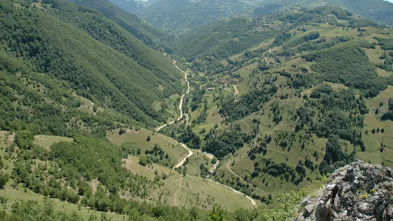
Photo: Ahmet Kagan Hancer, CC BY-SA 4.0, cropped
The Evliya Çelebi Way is a long-distance walking and riding route in north-west Anatolia. It follows the first weeks of the journey that the Ottoman traveller Evliya Çelebi set out on in 1671, on his way from Istanbul to Mecca, and which he described in his ten-volume Book of Travels (Seyahatname). The route starts at Hersek, a village on the southern shore of the Gulf of İzmit, and runs south through İznik, the Domaniç mountains and Kütahya, his family's home town, to Simav. It was opened in 2009 by a group of Turkish and British riders and historians, and is looked after by the Culture Routes Society (Kültür Rotaları Derneği), which also runs the Lycian Way.
There are two versions. The riding route is about 650 km and takes about 25 days. The walking route is about 330 km in about 22 days: it leaves out two long, flat sections, which walkers cross by bus. This guide joins them into one line from Hersek to Simav, 611 km in 31 stages (about 19.7 km each), so you can see the whole way. The walking route is stages 1-4, 7-15 and 25-31.
The route
From Hersek the trail climbs through olive groves and woods over the hills behind the Gulf of İzmit, past the Ottoman Valideköprü bridge, to Kızderbent and Mahmudiye, then drops to İznik on its lake. İznik, ancient Nicaea, still has most of its Roman and Byzantine walls and gates, the Hagia Sophia (a mosque again) and its famous tile workshops. South of İznik the path crosses a ridge to the ruined village of Eski Çelebi.
The riders' route then crosses the farmland of the Yenişehir plain to Sungurpaşa (stages 5-6); walkers usually ride this part by minibus. From Sungurpaşa the walking route climbs through villages and orchards to the tomb of Baba Sultan, Cerrah, Deydinler and Hacıkara, near the Oylat caves and hot springs, then into the forests of the Domaniç mountains. Here are the highest and wildest days, over summer pastures (yayla) such as Kuruluk and the ridge before the Kocayayla pass (about 1,560 m), to Çukurca, Elmalı and Şenlikköy. The walking section ends at Köprüören, on the edge of Kütahya.
Between Kütahya and Uşak the riders' route goes south-east past Altıntaş and Zafer Airport, round the west side of Afyonkarahisar and west through Banaz district to Mesudiye, near Uşak (stages 16-24). It is long, flat and on farm tracks and quiet roads; walkers take the bus from Kütahya to Uşak. The last walking section climbs from Mesudiye through the pine forest at Yediçeşme to Eskigüney and Gediz, rebuilt after the 1970 earthquake, then over the hills by Eskigediz, Gürlek and Şaphane to the hot-spring town of Simav. Evliya praised the springs at Eynal, just outside Simav, as having no equal on earth.
The highest point is about 1,560 m and the total climb about 12,900 m (8,800 m on the walking route).
Highlights
- İznik: city walls, gates, Hagia Sophia, the Green Mosque and tile workshops, on a big lake
- The Domaniç mountains: beech and pine forest, summer pastures and the highest point of the route
- Kütahya: the old town, the castle and the tile tradition of Evliya's home town
- Simav and Eynal: the end of the way and the hot springs Evliya wrote about
When to walk the Evliya Çelebi Way
The route society advises April to June and September to early November, but summer forest bans now decide the season. Each year the governors close forests because of fire risk, and most of the walking route is forest: in 2026 Bursa banned entry from 20 June to 15 October and Kütahya until 31 October, and Kocaeli, Yalova, Uşak and Afyonkarahisar had similar bans in 2025. Walking the forest sections during a ban can be fined. Go from mid-April to early June, or in November, and check each province's valilik website first. The Domaniç mountains can have snow from December to March.
How many days do you need?
The official walking route takes about 22 walking days, plus rest days and the two bus transfers. Add a day in İznik and one in Kütahya. The riders' stages between Kütahya and Mesudiye are long (up to 41 km) because riders cover 25 to 40 km a day. Many walkers do one section, such as Hersek to İznik (4 days).
Getting there and logistics
Take the ferry from Yenikapı in Istanbul to Yalova (about 80 minutes), then a minibus to Altınova; Hersek is about 4 km north. Kütahya, Uşak and Simav have intercity bus stations (otogar), and Zafer Airport (KZR) has domestic flights. From Simav, take a bus to Kütahya, Uşak or İzmir to travel on.
Permits: none. There is no fee and no booking system.
Accommodation: hotels and teachers' guesthouses (öğretmenevi) in the towns: İznik, Kütahya, Gediz, Şaphane and Simav on the route, and Karamürsel, İnegöl, Uşak and Afyonkarahisar a taxi ride off it. Near Hacıkara, the Oylat hot springs have three spa hotels about 3 km off the trail. Teachers' guesthouses take other guests only when they have room. No beds were found in Yenişehir, Çukurca or Altıntaş. In villages, ask at the teahouse (kahve) for a guest room (köy odası) or a place to camp, and offer to pay. Carry a tent: the official list of camping places, with fountains and troughs, is in the stage pages.
Money and phone: Turkish lira. There are ATMs and card payments in the towns, cash only in the villages. Mobile signal is patchy in the Domaniç forests.
Waymarking and navigation: signposts went up in Yalova and Bursa provinces by 2015, and waymarking between Altınova and Kütahya started in 2016; further south marks are sparse. The Culture Routes Society still lists the route, but its updates, campsite list and GPS files (January 2015) have not been revised since 2016, and walkers report few marks. Much of the route is on unmapped paths, so carry the official GPS files and the guidebook (English, 2011, still sold by the society, or the Turkish edition Evliya Çelebi Yolu).
What to pack
A light tent, sleeping bag and mat, a stove, a water filter and room for 2 litres of water, sun hat, a warm layer and a waterproof, a headtorch, a first-aid kit and a phone with the GPS track offline. Village shops sell bread, cheese, olives and biscuits; carry food for the forest days.
Difficulty and safety
The walking is mostly easy to moderate, on forest tracks, field paths and old mule tracks, with climbs of 400 to 800 m on the mountain days. The hard part is route-finding and self-reliance: few people speak English away from the towns, and there are no huts or rescue posts. Call 112 in an emergency: since 2021 it is the only number for ambulance, police, gendarmerie, fire and forest fires. For a lost or injured walker, 112 sends AFAD and the gendarmerie's search-and-rescue teams (JAK). Large sheepdogs guard the flocks: stop and shout for the shepherd. Do not walk in mist or heavy rain on the mountain sections, respect the forest bans, light fires only in existing fireplaces outside them, and tell someone your plan each day.
Evliya Çelebi Way map
The whole Evliya Çelebi Way with its 31 stages, Hersek to Simav. Tap a stage on the map to open it. To follow the route with GPS and offline maps on the trail, open it in the free Outest app.
The 31 stages
The whole Evliya Çelebi Way from Hersek on the Gulf of İzmit to Simav, in the guidebook's day sections: over the hills to İznik, across the Yenişehir plain, through İnegöl's villages and the Domaniç mountains to Kütahya, along the riders' route past Altıntaş and Afyonkarahisar to Mesudiye near Uşak, then over the hills by Gediz and Şaphane to Simav. Stages 5-6 and 16-24 are the riders' sections that walkers usually cross by bus. Walking times allow for rough tracks and route-finding. Each stage page has a map, elevation profile, places to sleep and the nearest help.
Emergency, hospitals and services
In an emergency call 112: one number for ambulance, police, gendarmerie and fire, free from any phone. Report forest fires on 112 too: the old 177 line was merged into it in 2021. For a lost or injured walker, 112 sends AFAD and the gendarmerie's search-and-rescue teams (JAK). 15 state hospitals with a 24-hour emergency department (acil servis) are within reach, from Yalova and İznik to Kütahya, Uşak, Gediz and Simav; every stage page lists the nearest one, plus pharmacies and shops on that stage.
Where to stay on the Evliya Çelebi Way
Hotels and teachers' guesthouses (öğretmenevi) in the towns, and the official campsites of the Evliya Çelebi Way in the villages and summer pastures, grouped by stage from Hersek to Simav. Listings were checked online in October 2026. Places marked "listed in a map or guide listing" appear on OpenStreetMap, in a travel guide or in the route society's list of campsites, but could not be confirmed on their own website in 2025-2026. Campsites are open ground with a fountain, not staffed sites. Most villages have no guesthouse: ask at the teahouse (kahve) for a guest room or a place to camp, and offer to pay even if it is refused. The route society says camping is largely unrestricted, but ask first near a village.
Hersek (trailhead)
3 places
- 3 with rooms
- 3 with meals
Hersek · Yalova
Hersek → Kızderbent
2 places
- 1 with rooms
- 1 camping
- 1 with meals
Karamürsel · Kızderbent
Kızderbent → Mahmudiye
1 place
- 1 camping
Mahmudiye
Mahmudiye → İznik
5 places
- 5 with rooms
- 5 with meals
İznik
İznik → Eski Çelebi
1 place
- 1 camping
Eski Çelebi
Yenişehir → Sungurpaşa
2 places
- 2 with rooms
- 2 with meals
İnegöl
Sungurpaşa → Babasultan
1 place
- 1 with rooms
- 1 with meals
İnegöl
Cerrah → Deydinler
2 places
- 1 with rooms
- 1 camping
Deydinler · İnegöl
Deydinler → Hacıkara
3 places
- 3 with rooms
- 3 with meals
Oylat
Hacıkara → Kuruluk Yaylası
1 place
- 1 camping
Kuruluk Yaylası
Çukurca → Elmalı
1 place
- 1 camping
Elmalı
Elmalı → Şenlikköy
1 place
- 1 camping
Şenlikköy
Şenlikköy → Köprüören
2 places
- 2 with rooms
- 2 with meals
Kütahya
Köprüören → Kütahya
2 places
- 2 with rooms
- 2 with meals
Kütahya
Kütahya → Gelinkaya
2 places
- 2 camping
Aloğlu · Gelinkaya
Altıntaş → Aydınlar
1 place
- 1 camping
Aydınlar
Aydınlar → Boyalı
2 places
- 1 with rooms
- 1 camping
- 1 with meals
Afyonkarahisar · Boyalı
Boyalı → Kınık
1 place
- 1 camping
Kınık
Kınık → Büyükoturak
1 place
- 1 camping
Büyükoturak
Büyükoturak → Dereköy
1 place
- 1 camping
Dereköy
Dereköy → Mesudiye
5 places
- 3 with rooms
- 2 camping
- 3 with meals
Mesudiye · Ovacık · Uşak
Mesudiye → Yediçeşme
1 place
- 1 camping
Yediçeşme
Yediçeşme → Eskigüney
1 place
- 1 camping
Eskigüney
Eskigüney → Gediz
3 places
- 2 with rooms
- 1 camping
- 2 with meals
Eskigediz · Gediz
Gediz → Gürlek
1 place
- 1 with rooms
- 1 with meals
Şaphane
Şaphane → Sarıçam
1 place
- 1 with rooms
- 1 with meals
Simav
Sarıçam → Simav
4 places
- 4 with rooms
- 2 with meals
Eynal · Simav
Plan your days
Pick any Evliya Çelebi Way stage in the free hike planner to see walking time, water to carry, calories, difficulty, the weather forecast and daylight.
More trail guides

Kaçkar Mountains Traverse
Turkey · Kaçkar Mountains · 34 km · 3 stages
Sultans Trail
Turkey · Eastern Thrace · 336 km · 15 stages
Mount Ararat Climb
Turkey · Ağrı · 12 km · 3 stages
Hittite Trail
Turkey · Çorum · 96 km · 7 stages
Troy Culture Route
Turkey · Çanakkale · 119 km · 7 stages
Independence Way
Turkey · Kastamonu · 94 km · 6 stages
Mysia Ways · Aladağlar Traverse · Tour du Mont Blanc · Alta Via 1 · GR 20 · John Muir Trail · Laugavegur · Cotswold Way · Kerry Way · Camino Finisterre · West Highland Way · Walker's Haute Route · Kungsleden · Tour of Monte Rosa · Coast to Coast Walk · Pembrokeshire Coast Path · Hadrian's Wall Path · South Downs Way · Dingle Way · Wicklow Way · Fishermen's Trail · Camino Portugués · Alta Via 2 · Malerweg · Peaks of the Balkans · Overland Track · Lycian Way · St Paul Trail · Camino Francés · Inca Trail · W Trek · Everest Base Camp Trek · Annapurna Circuit · Kumano Kodo Nakahechi · Camino del Norte · Via Francigena · GR10 · Pennine Way · Carian Trail · Phrygian Way · Rheinsteig · Westweg · Goldsteig · GR54 Tour des Écrins · Via Alpina · Path of the Gods · Cinque Terre Trail · Alta Via 4 · GR221 Dry Stone Route · Stubai High Trail · Milford Track · Routeburn Track · Kepler Track · Tongariro Northern Circuit · Larapinta Trail · Great Ocean Walk · West Coast Trail · Wonderland Trail · Teton Crest Trail · Annapurna Base Camp Trek · Markha Valley Trek · Salkantay Trek · Huayhuash Circuit · Kilimanjaro Machame Route · Toubkal Circuit · Jordan Trail: Dana to Petra · Torres del Paine O Circuit · Abel Tasman Coast Track · Three Capes Track · Mestia to Ushguli Trek · Nakasendo Way · Berg Lake Trail · Skyline Trail (Jasper) · Fitz Roy & Cerro Torre Loop · Santa Cruz Trek · Otter Trail · Fish River Canyon Hiking Trail · Camino Primitivo · Camino Inglés · Eagle Walk (Adlerweg) · Berliner Höhenweg · Cape Wrath Trail · Great Glen Way · Offa's Dyke Path · Cleveland Way · Rota Vicentina Historical Way · Via Podiensis (GR 65) · Heaphy Track · Queen Charlotte Track · Cape to Cape Track · Rockwall Trail · Juan de Fuca Marine Trail · Quilotoa Loop · Nahuel Huapi Traverse · Ala Kul Trek · Tiger Leaping Gorge High Trail · Mount Kenya Sirimon–Chogoria Traverse · Ghorepani Poon Hill Trek · Kilimanjaro Lemosho Route · Lebanon Mountain Trail · Kokoda Track · Chilkoot Trail · Lost City Trek · Choquequirao Trek · GR R2 Réunion · M'Goun Traverse
Hike it with the route in your pocket
Outest has the Evliya Çelebi Way route offline, with elevation, water and village points, and a trail guide you can ask about stages, weather and where to sleep.