
Berliner Höhenweg hiking guide: route map, stages & where to stay
The Berliner Höhenweg (Zillertaler Runde): about 80 km hut to hut through the Zillertal Alps in Tyrol, from Finkenberg over the Schönbichler Horn (3,134 m) to the Karl-von-Edel-Hütte above Mayrhofen. Usually 8 stages, sleeping in eight Alpenverein huts.
Best time to hike the Berliner Höhenweg →

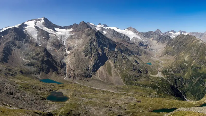
Photo: Whgler, CC BY-SA 3.0, cropped
The Berliner Höhenweg (Berlin High Trail), also called the Zillertaler Runde, is the classic hut-to-hut trek of the Zillertal Alps in Tyrol, Austria. It links eight Alpenverein huts in a wide arc around the side valleys above Ginzling, from Finkenberg to the Karl-von-Edel-Hütte above Mayrhofen. The Alpenverein gives more than 70 km and about 6,700 m of climbing for the hut-to-hut route, usually walked in 8 days. After the first climb the path stays high, mostly between 1,900 and 3,134 m, and crosses one rocky pass after another, facing the glaciers of the main Zillertal ridge on the Italian border. All of it lies in the Hochgebirgs-Naturpark Zillertaler Alpen, and it is waymarked red and white.
The route
The trail starts in Finkenberg, at the Teufelsbrücke, and climbs through forest on the Hermann-Hecht-Weg to the Gamshütte. The second day is long and lonely: about 15 km of narrow path across steep grass slopes, the Graue Platte, the Pitzenalm and the Rifflerrinne to the Friesenberghaus and its lake. A short balcony path then leads to the Olpererhütte, with its small suspension bridge and the view over the Schlegeis reservoir. From there the route drops to the reservoir, follows its shore road and climbs to the Furtschaglhaus. The highest day crosses the Schönbichler Horn (3,134 m) on a cable-protected ridge and goes down past the Waxegg glacier moraine to the historic Berliner Hütte. Next come the Mörchenscharte (2,872 m) and a steep descent into the Floitengrund to the Greizer Hütte, then the Lapenscharte (2,701 m) and the Elsenklamm ledge to the Kasseler Hütte. The last day follows the Aschaffenburger Höhenweg, the "Siebenschneidensteig", over seven ridges and through boulder fields to the Karl-von-Edel-Hütte.
This guide follows the route as mapped on OpenStreetMap and splits it into 8 hut-to-hut stages, about 9.9 km each. The line ends at the Karl-von-Edel-Hütte. From there it is one more hour down to the Ahornbahn top station and the cable car to Mayrhofen (the last car down is at 17:00), or about 4 hours on foot via path 42 and the Wirtshaus Alpenrose. Those last kilometres are not part of the stage table.
Highlights
- The Schönbichler Horn (3,134 m): the highest point, a few steps off the path, with a wide view over the glaciers of the main ridge
- The Olpererhütte: the little suspension bridge above the Schlegeis reservoir, a favourite photo spot
- The Berliner Hütte (1879): the first hut in the Zillertal, with wood-panelled dining rooms, and a listed building since 1997
- The Friesenbergsee and the Schwarzsee: high mountain lakes by the Friesenberghaus and on the way to the Mörchenscharte
- The Siebenschneidensteig: a wild, empty day over seven ridges between the Kasseler Hütte and the Karl-von-Edel-Hütte
When to walk the Berliner Höhenweg
The huts are open from mid-June to mid- or late September. In 2026 the Olpererhütte opened first (29 May) and most others opened between 11 and 15 June. The Friesenberghaus closed first (17 September); most others closed on 19 or 20 September. The best time is July to mid-September. In June and early July snow can lie on the Schönbichler Horn, the Mörchenscharte and the north-facing slopes of stage 2, and the huts advise against those crossings in snow. Afternoon thunderstorms are common in summer, so start early. In September the trail is quieter, but check each hut's closing date.
How many days do you need?
Most hikers take 8 days from Finkenberg, or 7 if they join stages 3 and 4 (Friesenberghaus to Furtschaglhaus via the Olpererhütte, about 6.5 hours). Every hut has a path down to a valley with buses, so it is easy to walk only part of the trail. Two good half-routes are Finkenberg to the Berliner Hütte (down to Breitlahner and Ginzling), and the Ahornbahn to the Berliner Hütte. Many people walk the loop the other way, starting with the Ahornbahn and the Karl-von-Edel-Hütte. The times in this guide are for the Finkenberg-to-Edelhütte direction.
Getting there and logistics
Mayrhofen is the end of the Zillertalbahn railway from Jenbach, on the main line between Innsbruck, Kufstein and Munich. Bus 4104 runs from Mayrhofen to Finkenberg (Teufelsbrücke). Bus 4102 goes to Ginzling and the Schlegeis reservoir. You can use it to start or leave the trail at the Olpererhütte or Furtschaglhaus stages. At the end, the Ahornbahn runs from Mayrhofen in summer (in 2026, 13 June to 31 October, 08:30 to 17:00). Innsbruck and Munich are the nearest airports. Hikers' taxis run up the Stilluptal and the Floitengrund, which shortens the walk to the Kasseler and Greizer huts if you need to leave or join the trail there.
Huts and booking
All eight huts are run by the German Alpine Club (DAV) sections. Most beds are booked online in the Alpenverein system (hut-reservation.org, also called alpsonline), which asks for card details and charges cancellation fees. For the Gamshütte, phone or email the hut. Book early for July and August, and book every night before you start. Half board (dinner and breakfast) costs about 40 to 50 euros on top of the bed. Alpine club members (ÖAV, DAV and partner clubs) pay much less for a bed. A hut sleeping bag is compulsory. Camping is not allowed, except an emergency bivouac above the tree line.
Money and phone signal
Bring enough cash. Some huts take cards (the Greizer Hütte adds a 1 euro fee), but not all. There are no shops and no cash machines on the trail; Finkenberg and Mayrhofen have both. Mobile signal is patchy. The Greizer Hütte has none, the Furtschaglhaus has an unreliable signal, and there is often none on the long crossings, so tell the next hut if your plans change.
What to pack
Walking boots with a stiff sole, waterproof jacket and trousers, warm layers, a hat and gloves, sun protection, a map (AV maps 35/1 and 35/2, 1:25,000), a head torch, a first-aid kit and a survival blanket. Carry 1.5 to 2 litres of water: there is none on stage 8. In early summer or after fresh snow you may need microspikes or crampons, and a via ferrata set is useful on the Schönbichler Horn. Keep the pack light, 8 to 12 kg at most.
Difficulty and safety
This is a demanding alpine trek for fit, experienced mountain walkers who are sure-footed and do not suffer from vertigo. There are no glaciers to cross and no climbing, but many exposed passages with fixed cables, ladders and steep grass. The Gamshütte to Friesenberghaus and Kasseler Hütte to Karl-von-Edel-Hütte stages are dangerous when wet, and the last one has no escape route to the valley. In August 2026 a hiker died after a fall on the cabled descent from the Mörchenscharte. No closures of the main route were reported for 2023 to 2026, but ask the hut wardens about snow and rockfall before each pass. In an emergency call 140 (mountain rescue) or 112. Rescue is expensive in Austria, so carry insurance that covers it.
Berliner Höhenweg map
The whole Berliner Höhenweg with its 8 stages, Finkenberg to the Karl-von-Edel-Hütte. Tap a stage on the map to open it. To follow the route with GPS and offline maps on the trail, open it in the free Outest app.
The 8 stages
The classic hut-to-hut stages of the Alpenverein brochure, from Finkenberg via the Gamshütte, the Friesenberghaus, the Olpererhütte, the Furtschaglhaus, the Schönbichler Horn and the Berliner Hütte, the Greizer Hütte and the Kasseler Hütte to the Karl-von-Edel-Hütte above Mayrhofen. The last hour down to the Ahornbahn cable car is not counted. Walking times allow for steep, rocky ground and cable-protected passages. Each stage page has a map, elevation profile, the huts on the way and the nearest help.
| # | Stage | Distance | Level |
|---|---|---|---|
| 1 | Finkenberg → Gamshütte | 7.0 km | hard |
| 2 | Gamshütte → Friesenberghaus | 14.8 km | hard |
| 3 | Friesenberghaus → Olpererhütte | 4.4 km | easy |
| 4 | Olpererhütte → Furtschaglhaus | 10.6 km | moderate |
| 5 | Furtschaglhaus → Berliner Hütte | 8.6 km | moderate |
| 6 | Berliner Hütte → Greizer Hütte | 10.7 km | hard |
| 7 | Greizer Hütte → Kasseler Hütte | 9.7 km | hard |
| 8 | Kasseler Hütte → Karl-von-Edel-Hütte | 13.2 km | hard |
Emergency, hospitals and services
In an emergency call 140 (Austrian mountain rescue) or 112; both reach the Leitstelle Tirol, which sends the Bergrettung and a helicopter. For an ambulance in the valley call 144. 2 hospitals and clinics are within reach; every stage page lists the nearest one, plus pharmacies, ATMs, shops and bus stops on that stage.
Where to stay on the Berliner Höhenweg
Alpenverein huts, a few private mountain inns and hotels in Finkenberg and Mayrhofen, grouped by stage from Finkenberg to the Karl-von-Edel-Hütte. Listings were checked online in October 2026. Places marked "listed by the tourist office" are on an official tourism listing but could not be confirmed on their own website. The huts are open only in summer and fill up in July and August, so book ahead.
Finkenberg (trailhead)
3 places
- 3 with rooms
- 3 with meals
Finkenberg · Finkenberg (Brunnhaus)
Finkenberg → Gamshütte
1 place
- 1 with rooms
- 1 with meals
Gamshütte
Gamshütte → Friesenberghaus
1 place
- 1 with rooms
- 1 with meals
Friesenberghaus
Friesenberghaus → Olpererhütte
2 places
- 2 with rooms
- 2 with meals
Olpererhütte · Schlegeis reservoir
Olpererhütte → Furtschaglhaus
1 place
- 1 with rooms
- 1 with meals
Furtschaglhaus
Furtschaglhaus → Berliner Hütte
3 places
- 3 with rooms
- 3 with meals
Berliner Hütte · Zemmgrund (Alpenrose) · Zemmgrund (Grawand)
Berliner Hütte → Greizer Hütte
1 place
- 1 with rooms
- 1 with meals
Greizer Hütte
Greizer Hütte → Kasseler Hütte
1 place
- 1 with rooms
- 1 with meals
Kasseler Hütte
Kasseler Hütte → Karl-von-Edel-Hütte
1 place
- 1 with rooms
- 1 with meals
Karl-von-Edel-Hütte
Mayrhofen (after the trail)
3 places
- 3 with rooms
Mayrhofen · Mayrhofen (Kumbichl)
Plan your days
Pick any Berliner Höhenweg stage in the free hike planner to see walking time, water to carry, calories, difficulty, the weather forecast and daylight.
More trail guides
Stubai High Trail
Austria · Tyrol · 81 km · 9 stages

Eagle Walk (Adlerweg)
Austria · Tyrol · 359 km · 24 stages

Tour du Mont Blanc
France · Italy · Switzerland · 166 km · 11 stages

Alta Via 1
Italy · Dolomites · 118 km · 11 stages

GR 20
France · Corsica · 184 km · 16 stages

John Muir Trail
USA · California · 353 km · 18 stages
Laugavegur · Cotswold Way · Kerry Way · Camino Finisterre · West Highland Way · Walker's Haute Route · Kungsleden · Tour of Monte Rosa · Coast to Coast Walk · Pembrokeshire Coast Path · Hadrian's Wall Path · South Downs Way · Dingle Way · Wicklow Way · Fishermen's Trail · Camino Portugués · Alta Via 2 · Malerweg · Peaks of the Balkans · Overland Track · Lycian Way · St Paul Trail · Camino Francés · Inca Trail · W Trek · Everest Base Camp Trek · Annapurna Circuit · Kumano Kodo Nakahechi · Camino del Norte · Via Francigena · GR10 · Pennine Way · Carian Trail · Evliya Çelebi Way · Kaçkar Mountains Traverse · Phrygian Way · Sultans Trail · Mount Ararat Climb · Hittite Trail · Troy Culture Route · Independence Way · Mysia Ways · Rheinsteig · Westweg · Goldsteig · GR54 Tour des Écrins · Via Alpina · Path of the Gods · Cinque Terre Trail · Alta Via 4 · GR221 Dry Stone Route · Milford Track · Routeburn Track · Kepler Track · Tongariro Northern Circuit · Larapinta Trail · Great Ocean Walk · West Coast Trail · Wonderland Trail · Teton Crest Trail · Annapurna Base Camp Trek · Markha Valley Trek · Salkantay Trek · Huayhuash Circuit · Kilimanjaro Machame Route · Toubkal Circuit · Jordan Trail: Dana to Petra · Torres del Paine O Circuit · Abel Tasman Coast Track · Three Capes Track · Mestia to Ushguli Trek · Nakasendo Way · Berg Lake Trail · Skyline Trail (Jasper) · Fitz Roy & Cerro Torre Loop · Santa Cruz Trek · Otter Trail · Fish River Canyon Hiking Trail · Camino Primitivo · Camino Inglés · Cape Wrath Trail · Great Glen Way · Offa's Dyke Path · Cleveland Way · Rota Vicentina Historical Way · Via Podiensis (GR 65) · Heaphy Track · Queen Charlotte Track · Cape to Cape Track · Rockwall Trail · Juan de Fuca Marine Trail · Quilotoa Loop · Nahuel Huapi Traverse · Ala Kul Trek · Tiger Leaping Gorge High Trail · Mount Kenya Sirimon–Chogoria Traverse · Ghorepani Poon Hill Trek · Kilimanjaro Lemosho Route · Lebanon Mountain Trail · Aladağlar Traverse · Kokoda Track · Chilkoot Trail · Lost City Trek · Choquequirao Trek · GR R2 Réunion · M'Goun Traverse
Hike it with the route in your pocket
Outest has the Berliner Höhenweg route offline, with elevation, water and village points, and a trail guide you can ask about stages, weather and where to sleep.