
Cape Wrath Trail hiking guide: route map, stages & where to stay
Scotland's wildest long walk: about 370 km (230 miles) of unwaymarked, often pathless ground from Fort William to Cape Wrath lighthouse, through Knoydart, Torridon and Assynt. Most walkers take 16 to 22 days, sleeping in bothies, a tent and the odd hotel or hostel.
Best time to hike the Cape Wrath Trail →

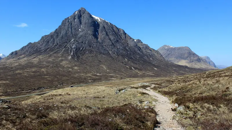
Photo: Michael Earnshaw, CC BY-SA 2.0, cropped
The Cape Wrath Trail is a long-distance walk through the north-west Highlands of Scotland, from Fort William to Cape Wrath, the north-west tip of mainland Britain. It is about 370 km (230 miles) long and is often called the hardest long walk in Britain. It is not an official trail: there are no waymarks, no fixed line and long sections have no path, so you must navigate with map and compass. Most walkers go south to north and take 16 to 22 days. This guide follows the main line used by the Cicerone guidebook and Walkhighlands, through Glenfinnan and Knoydart.
The route
The walk starts with a ten-minute passenger ferry across Loch Linnhe from Fort William to Camusnagaul. A quiet road and the Cona Glen track lead to Glenfinnan, then glens and passes take you through Glen Dessarry to Sourlies bothy on Loch Nevis and over to Barrisdale in Knoydart. After Kinloch Hourn the route crosses the Bealach Coire Mhalagain below The Saddle, at about 730 m the highest point of the trail, and drops to Shiel Bridge and Morvich in Kintail.
North of Kintail you pass the Falls of Glomach, cross the empty country around Maol Bhuidhe and Bendronaig to Strathcarron, then walk through the Coulin hills to Kinlochewe below Beinn Eighe. The next days reach Shenavall bothy under An Teallach, Inverlael near Ullapool, Oykel Bridge and the limestone country of Inchnadamph. In Assynt the route passes below Eas a' Chual Aluinn, Britain's highest waterfall, to Glencoul and Glendhu, then crosses rocky moorland to Rhiconich. The last two days follow the coast past Kinlochbervie to Sandwood Bay, one of Scotland's finest beaches, and over boggy moor to the lighthouse at Cape Wrath.
This guide splits the line from the Camusnagaul ferry landing into 15 stages, about 25.3 km each. The stage ends are where walkers sleep: bothies, campsites, hotels or a good place to pitch a tent. Many walkers add rest days, for example at Kinlochewe or Ullapool.
Highlights
- Knoydart: Sourlies bothy on Loch Nevis and the bay at Barrisdale
- Falls of Glomach: a 113 m waterfall with a steep, exposed path beside it
- Fisherfield: the wilderness around Shenavall bothy below An Teallach
- Assynt: Eas a' Chual Aluinn and the bothies on Loch Glencoul and Loch Glendhu
- Sandwood Bay and Cape Wrath: a remote beach, sea stacks and the lighthouse at the end of the land
When to walk the Cape Wrath Trail
The usual season is April to early October. May and June are often the driest months and have very long days, and midges are fewer than in July and August. September is good too, but it is the start of the stag-stalking season. Winter walking is only for experienced, well-equipped parties. Expect rain, strong wind and low cloud in any month, and check the Mountain Weather Information Service forecast.
Deer stalking and bothy closures
Red deer stags are shot on many estates from about July to 20 October; the busiest period is mid-September to 20 October, and the hind cull runs from 21 October to 15 February. Stalking rarely happens on Sundays. Check Heading for the Scottish Hills, read estate notices and keep to paths and tracks. Several bothies close or ask you to phone first in the stalking season: Maol Bhuidhe, Shenavall, Coire Fionnaraich and Knockdamph are closed for some or all of September and October, and Reay Forest Estate asks you to phone before using Glencoul and Glendhu. Always carry a tent.
Difficulty
This is a hard, committing walk. Days are long (often 25 to 34 km, 15 to 21 miles), on rough, wet and pathless ground with a heavy pack, and the bog is relentless. Walkhighlands grades most stages four boots out of five. There are many river crossings without bridges; after heavy rain some, such as the ford before Maol Bhuidhe and the Strath Chailleach near Sandwood Bay, can be impossible. Wait for the water to drop or take a known alternative, and never cross a river in spate. Large parts of the route are a day or more from a road, so you must be self-sufficient.
Getting there and away
Fort William has trains from Glasgow and the overnight Caledonian Sleeper from London, plus Citylink buses. The Camusnagaul passenger ferry (Highland Ferries) leaves from the town pier Monday to Saturday, at 08:00, 10:30, 12:20 and 16:15, with a 17:30 sailing on request; the adult fare is £2. There is no ferry on Sunday except by special arrangement for £100, so plan your start day around it.
At the end there is no road. A seasonal minibus runs from the lighthouse to the Kyle of Durness, and a small foot-passenger ferry crosses to Keoldale, 4 km from Durness. They usually run from May to September, depend on tides, weather and military firing, and need booking a day ahead: walkers pay £15 for the bus and the ferry separately (about £10 single in 2026). Outside the season you must walk back to Sandwood Bay and Blairmore. From Durness, bus 805 runs to Inverness on weekdays.
Along the way, Glenfinnan and Strathcarron have railway stations, and Shiel Bridge and Inverlael are on bus routes.
Accommodation and resupply
Most nights are spent in a tent or in a bothy. Bothies are free, unlocked shelters, most of them looked after by the Mountain Bothies Association; you cannot book them, groups of six or more should not use them, and there is no rubbish collection. Wild camping is legal under the Scottish Outdoor Access Code if you camp lightly and leave no trace. There are hotels, B&Bs, hostels or campsites at Glenfinnan, Shiel Bridge and Morvich, Strathcarron, Kinlochewe, Oykel Bridge, Inchnadamph, Kylesku and Rhiconich, but each has only a few rooms, so book ahead.
Shops are few. Buy four to five days of food in Fort William: the next shop is at Shiel Bridge. After that you can buy food at Kinlochewe, in Ullapool (a full resupply by bus from Inverlael), at Kinlochbervie and Badcall, and in Durness at the end. Many walkers post food parcels ahead; Glenshiel Campsite advertises this, and others may accept parcels if you ask first.
Money and phone signal
Carry cash as well as a card: some small B&Bs and honesty boxes take only cash. There are cash machines in Fort William and Ullapool. Mobile signal is absent for long stretches, including Barrisdale and most of Knoydart. Carry a personal locator beacon or a satellite messenger, and leave your route and dates with someone at home.
What to pack
A light, storm-proof tent, a warm sleeping bag, a stove, full waterproofs, footwear that copes with constant wet, map and compass plus a GPS with offline maps, a water filter, a head torch, a midge net and repellent, a tick remover, and a first-aid and blister kit.
Safety
In an emergency call 999 or 112 and ask for the Police, then Mountain Rescue. If you are deaf or cannot speak, register for emergencySMS before you go. Before the last two stages check the Ministry of Defence firing times for the Cape Wrath range: when red flags fly, access is forbidden.
Cape Wrath Trail map
The whole Cape Wrath Trail with its 15 stages, Fort William to Cape Wrath. Tap a stage on the map to open it. To follow the route with GPS and offline maps on the trail, open it in the free Outest app.
The 15 stages
Fifteen stages from the Camusnagaul ferry landing across Loch Linnhe from Fort William to the lighthouse at Cape Wrath, via Glenfinnan, Knoydart, Kintail, Strathcarron, Kinlochewe, Shenavall, Inverlael, Oykel Bridge, Assynt, Rhiconich and Sandwood Bay. The route is unwaymarked and often pathless, and walking times allow for bog, river crossings and a full pack. Each stage page has a map, elevation profile, bothies and places to sleep, stalking closures and the nearest help.
| # | Stage | Distance | Level |
|---|---|---|---|
| 1 | Camusnagaul → Glenfinnan | 34.4 km | hard |
| 2 | Glenfinnan → A' Chuil | 18.8 km | hard |
| 3 | A' Chuil → Barrisdale | 26.0 km | hard |
| 4 | Barrisdale → Morvich | 32.9 km | hard |
| 5 | Morvich → Maol Bhuidhe | 22.9 km | hard |
| 6 | Maol Bhuidhe → Strathcarron | 18.9 km | hard |
| 7 | Strathcarron → Kinlochewe | 29.5 km | hard |
| 8 | Kinlochewe → Shenavall | 27.0 km | hard |
| 9 | Shenavall → Inverlael | 19.0 km | hard |
| 10 | Inverlael → Oykel Bridge | 34.1 km | hard |
| 11 | Oykel Bridge → Inchnadamph | 29.8 km | hard |
| 12 | Inchnadamph → Kylesku | 26.8 km | hard |
| 13 | Kylesku → Rhiconich | 28.3 km | hard |
| 14 | Rhiconich → Sandwood Bay | 19.3 km | hard |
| 15 | Sandwood Bay → Cape Wrath | 11.8 km | moderate |
Emergency, hospitals and services
In an emergency call 999 or 112 and ask for the Police, then Mountain Rescue. For urgent medical advice that is not life-threatening call NHS 24 on 111. 3 hospitals with a 24-hour emergency department (A&E) serve the route, in Fort William, Broadford on Skye and Inverness; from remote stages serious cases are flown out by helicopter. Mobile signal is absent for long stretches, so carry a personal locator beacon or satellite messenger. Every stage page lists the nearest hospital and GP surgery.
Where to stay on the Cape Wrath Trail
Bothies, campsites, hotels, B&Bs and hostels, grouped by stage from Fort William to Cape Wrath. Listings were checked online in October 2026. Places marked "listed, not confirmed" appear on a public listing (OpenStreetMap, VisitScotland, CAMRA or a booking site) or have an out-of-date website, and could not be confirmed for 2026. Bothies are free, unlocked shelters with no booking; wild camping is legal under the Scottish Outdoor Access Code if you camp lightly and leave no trace. Most nights are spent in a tent or a bothy, so carry a tent and stove.
Camusnagaul (trailhead)
5 places
- 3 with rooms
- 1 camping
- 2 with meals
Fort William · Glen Nevis
Camusnagaul → Glenfinnan
4 places
- 3 with rooms
- 2 with meals
Glenfinnan
Glenfinnan → A' Chuil
3 places
- 3 with rooms
Glen Dessarry · Glen Finnan · Glen Pean
A' Chuil → Barrisdale
4 places
- 3 with rooms
- 1 camping
Barrisdale · Loch Nevis
Barrisdale → Morvich
5 places
- 3 with rooms
- 2 camping
- 2 with meals
Kinloch Hourn · Morvich · Ratagan · Shiel Bridge
Morvich → Maol Bhuidhe
1 place
- 1 with rooms
Killilan
Maol Bhuidhe → Strathcarron
2 places
- 2 with rooms
- 1 with meals
Bendronaig · Strathcarron
Strathcarron → Kinlochewe
5 places
- 3 with rooms
- 1 camping
- 1 with meals
Coulags · Kinlochewe
Kinlochewe → Shenavall
1 place
- 1 with rooms
Strath na Sealga
Shenavall → Inverlael
3 places
- 3 with rooms
Clachan (Loch Broom) · Lael · Ullapool
Inverlael → Oykel Bridge
3 places
- 3 with rooms
- 1 with meals
Duag Bridge · Glen Douchary · Oykel Bridge
Oykel Bridge → Inchnadamph
2 places
- 2 with rooms
- 1 with meals
Inchnadamph
Inchnadamph → Kylesku
3 places
- 3 with rooms
- 1 with meals
Kylesku · Loch Glencoul · Loch Glendhu
Kylesku → Rhiconich
1 place
- 1 with rooms
- 1 with meals
Rhiconich
Rhiconich → Sandwood Bay
5 places
- 2 with rooms
- 1 camping
- 2 with meals
Badcall (Loch Inchard) · Inshegra · Kinlochbervie · Sandwood Bay
Sandwood Bay → Cape Wrath
4 places
- 2 with rooms
- 1 with meals
Cape Wrath · Kearvaig · Strath Chailleach
Durness (after the trail)
3 places
- 2 with rooms
- 1 camping
- 1 with meals
Durness
Plan your days
Pick any Cape Wrath Trail stage in the free hike planner to see walking time, water to carry, calories, difficulty, the weather forecast and daylight.
More trail guides
West Highland Way
Scotland · 153 km · 8 stages

Great Glen Way
Scotland · Highlands · 120 km · 6 stages

Tour du Mont Blanc
France · Italy · Switzerland · 166 km · 11 stages

Alta Via 1
Italy · Dolomites · 118 km · 11 stages

GR 20
France · Corsica · 184 km · 16 stages

John Muir Trail
USA · California · 353 km · 18 stages
Laugavegur · Cotswold Way · Kerry Way · Camino Finisterre · Walker's Haute Route · Kungsleden · Tour of Monte Rosa · Coast to Coast Walk · Pembrokeshire Coast Path · Hadrian's Wall Path · South Downs Way · Dingle Way · Wicklow Way · Fishermen's Trail · Camino Portugués · Alta Via 2 · Malerweg · Peaks of the Balkans · Overland Track · Lycian Way · St Paul Trail · Camino Francés · Inca Trail · W Trek · Everest Base Camp Trek · Annapurna Circuit · Kumano Kodo Nakahechi · Camino del Norte · Via Francigena · GR10 · Pennine Way · Carian Trail · Evliya Çelebi Way · Kaçkar Mountains Traverse · Phrygian Way · Sultans Trail · Mount Ararat Climb · Hittite Trail · Troy Culture Route · Independence Way · Mysia Ways · Rheinsteig · Westweg · Goldsteig · GR54 Tour des Écrins · Via Alpina · Path of the Gods · Cinque Terre Trail · Alta Via 4 · GR221 Dry Stone Route · Stubai High Trail · Milford Track · Routeburn Track · Kepler Track · Tongariro Northern Circuit · Larapinta Trail · Great Ocean Walk · West Coast Trail · Wonderland Trail · Teton Crest Trail · Annapurna Base Camp Trek · Markha Valley Trek · Salkantay Trek · Huayhuash Circuit · Kilimanjaro Machame Route · Toubkal Circuit · Jordan Trail: Dana to Petra · Torres del Paine O Circuit · Abel Tasman Coast Track · Three Capes Track · Mestia to Ushguli Trek · Nakasendo Way · Berg Lake Trail · Skyline Trail (Jasper) · Fitz Roy & Cerro Torre Loop · Santa Cruz Trek · Otter Trail · Fish River Canyon Hiking Trail · Camino Primitivo · Camino Inglés · Eagle Walk (Adlerweg) · Berliner Höhenweg · Offa's Dyke Path · Cleveland Way · Rota Vicentina Historical Way · Via Podiensis (GR 65) · Heaphy Track · Queen Charlotte Track · Cape to Cape Track · Rockwall Trail · Juan de Fuca Marine Trail · Quilotoa Loop · Nahuel Huapi Traverse · Ala Kul Trek · Tiger Leaping Gorge High Trail · Mount Kenya Sirimon–Chogoria Traverse · Ghorepani Poon Hill Trek · Kilimanjaro Lemosho Route · Lebanon Mountain Trail · Aladağlar Traverse · Kokoda Track · Chilkoot Trail · Lost City Trek · Choquequirao Trek · GR R2 Réunion · M'Goun Traverse
Hike it with the route in your pocket
Outest has the Cape Wrath Trail route offline, with elevation, water and village points, and a trail guide you can ask about stages, weather and where to sleep.