
Coast to Coast Walk hiking guide: route map, stages & where to stay
Wainwright's Coast to Coast Walk: about 300 km (190 miles) across northern England from St Bees on the Irish Sea to Robin Hood's Bay on the North Sea, through the Lake District, the Yorkshire Dales and the North York Moors. A National Trail since March 2026; most walkers take 12 to 15 days and sleep in inns, B&Bs, hostels and campsites.
Best time to hike the Coast to Coast Walk →

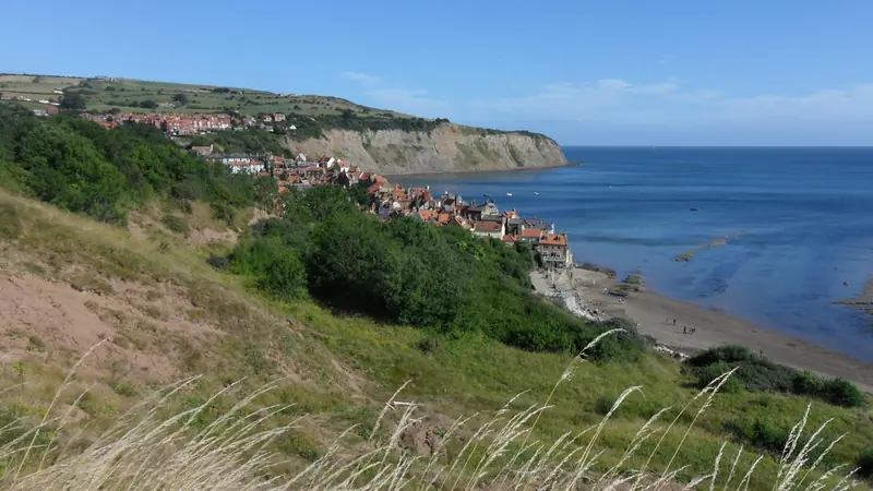
Photo: Kreuzschnabel, CC BY-SA 3.0, cropped
Wainwright's Coast to Coast Walk crosses northern England from the Irish Sea to the North Sea. It runs for about 300 km (190 miles) from St Bees in Cumbria to Robin Hood's Bay in North Yorkshire and passes through three national parks: the Lake District, the Yorkshire Dales and the North York Moors. The fell walker and writer Alfred Wainwright described the route in his 1973 book *A Coast to Coast Walk*. For more than 50 years it was an unofficial and largely unsignposted route on public footpaths, tracks and quiet roads. On 26 March 2026 it officially opened as the Coast to Coast Path National Trail, with new signs, better paths and some small changes to the line. Most people walk it from west to east, but it is signposted in both directions.
The route
The walk starts at the sea wall in St Bees. By tradition you dip your boots in the Irish Sea and pick up a pebble to carry across England. The first hours follow the cliffs of St Bees Head, then the path turns inland through farmland and villages and climbs Dent Fell to Ennerdale Bridge. The next day follows the south shore of Ennerdale Water and a long forest track to Black Sail youth hostel. It then climbs beside Loft Beck to an old slate tramway and drops past Honister slate mine into Borrowdale and Rosthwaite. From Rosthwaite the path climbs over Greenup Edge and down Far Easedale to the edge of Grasmere. Then it climbs again to Grisedale Tarn and goes down the long Grisedale valley to Patterdale near Ullswater. The hardest mountain day goes past Angle Tarn to Kidsty Pike, at 780 m the highest point of the walk, and then down to the long reservoir of Haweswater and on past Shap Abbey to the village of Shap.
After Shap the Lake District is behind you. The route crosses the M6 on a footbridge and goes over wide limestone moors, past Orton Scar and Smardale Bridge, to the market town of Kirkby Stephen. A steady climb leads to the stone cairns of Nine Standards Rigg on the main watershed of England, where new flagstones cross the worst of the peat bog, and down to Keld at the head of Swaledale, about halfway. From Keld the main route goes high over the old lead mines of Gunnerside Moor to Reeth; a gentler low route follows the River Swale through hay meadows. An easy day along the Swale leads to Richmond, with its castle and big cobbled market place. Then comes a long, flat crossing of the Vale of Mowbray on field paths and lanes through Bolton-on-Swale and Danby Wiske to Ingleby Cross. Here the signed route goes north to cross the busy A19 on the Black Swan bridge, which adds about 7 km.
The last part crosses the North York Moors. The path joins the Cleveland Way and follows the steep edge of the Cleveland Hills over Carlton Moor and Cringle Moor, past the Wainstones rocks, to Clay Bank Top. Next it crosses Urra Moor and follows an old railway track across the heather moors to the Lion Inn on Blakey Ridge, then Glaisdale Rigg down into the Esk valley at Glaisdale. The final day goes through woods to Egton Bridge and Grosmont, over the moor to Littlebeck and the Falling Foss waterfall, then to the coast near Hawsker. The cliff path leads south to Robin Hood's Bay, where you walk down the steep main street to the slipway, wet your boots in the North Sea and leave your pebble on the beach.
This guide follows the National Trail line as mapped on OpenStreetMap and splits it into 14 stages, about 21.6 km each, ending in the villages where walkers usually sleep. The elevation profile used here adds up to about 6,500 m of climbing in total.
Highlights
- St Bees Head: red sandstone cliffs above the Irish Sea on the first morning
- Ennerdale and Black Sail: a quiet lake, a long wild valley and a youth hostel with no road access
- Borrowdale and Greenup Edge: green valleys, stone walls and the first big fell crossing
- Kidsty Pike and Haweswater: the highest point of the walk, at 780 m, with views over the eastern fells
- Nine Standards Rigg: a row of old stone cairns on the watershed of England
- Swaledale: stone barns, hay meadows and the lead-mining remains above Gunnerside
- Richmond: an 11th-century castle above the River Swale and one of the largest cobbled market places in England
- The Cleveland Hills: a roller-coaster ridge along the edge of the moors with wide views over the plain
- Robin Hood's Bay: a steep old fishing village where the walk ends on the beach
When to walk the Coast to Coast Walk
The trail is open all year, but the best time is from spring to autumn. The longest days are in May, June and July. In winter the days are short, the Lake District fells can have snow and ice, and some places to stay close: for example Keld Lodge reopens on 1 April 2027, and the campsite in Keld is open from Easter to the end of September. Rain is possible at any time of year, and the moors are wet and boggy after rain. Rooms are few in small villages such as Ennerdale Bridge, Keld, Danby Wiske and Glaisdale, so book early. The National Trail team suggests starting on a Monday or Tuesday, when rooms are easier to find.
How many days do you need?
Most people take 12 to 15 days. The 14 stages in this guide are a common two-week plan with days of 11 to 31 km. Shap to Kirkby Stephen (about 31 km) and Glaisdale to Robin Hood's Bay (about 30 km) are the longest days. Fit walkers join Rosthwaite to Patterdale and Richmond to Ingleby Cross into single days and finish in 12 days. Many people add a rest day, for example in Grasmere, Kirkby Stephen or Richmond. You can also walk it in parts: there are railway stations at St Bees, Kirkby Stephen, Glaisdale, Egton and Grosmont.
Getting there and logistics
St Bees has a station on the Cumbrian Coast railway, with trains from Carlisle or Lancaster. The nearest large airports are Manchester and Newcastle. From Robin Hood's Bay a bus runs to Whitby, where trains go to Middlesbrough.
You sleep in inns, B&Bs, hotels, hostels, bunkhouses and campsites. In England there is no general right to wild camp. In the Lake District, wild camping is technically not allowed without the landowner's permission, but the national park says it is normally tolerated if you camp for one night, high on the fells above the highest fell wall, with one or two small tents, no fires and no trace left. Everywhere else, use a campsite or ask the landowner. Several companies carry your bags between overnight stops, for example Sherpa Van and Coast to Coast Packhorse (based in Kirkby Stephen); many walking companies also book the whole trip. Shops are few between the towns, so carry food and water for the day. Mobile signal is patchy, especially in the Lake District valleys and on the moors, so carry the route offline and a paper map.
Check diversions on the National Trails website before you go. In 2026 the start at St Bees is diverted because of cliff falls on St Bees Head, and the official line crosses the A19 on the Black Swan bridge, not on the road.
Difficulty
The Coast to Coast is a demanding walk. The western part through the Lake District is the hardest: long climbs and descents on rocky paths, crossings of high, open ground such as Greenup Edge and Kidsty Pike, and hard navigation in mist. In poor weather stay on the main valley routes: the high alternatives over Red Pike and High Stile, Helm Crag, Helvellyn or St Sunday Crag are only for clear days. If the forecast for Kidsty Pike is bad, wait or take a lower option from your guidebook. Nine Standards Rigg and the North York Moors have peat bog and wet ground, and the Cleveland Hills have short, steep climbs. The middle section from Richmond to Ingleby Cross is flat but long, with road walking and fields with cattle and sheep. Keep dogs on a short lead near livestock, and let go of the lead if cattle chase you. Good boots, waterproofs, warm layers, a map and compass are needed. In an emergency call 999 or 112 and ask for the Police, then Mountain Rescue.
History
Alfred Wainwright (1907–1991) is best known for his hand-drawn guides to the Lakeland fells. He planned this walk himself, using public rights of way, and described it in *A Coast to Coast Walk*, published in 1973. He did not want it to become the only way across England: he hoped walkers would plan their own routes. Even so, his route became one of the most popular long walks in Britain. For decades it had no official status and almost no signs, and parts of it, such as Nine Standards Rigg, were badly eroded. On 12 August 2022 the government announced that it would become a National Trail. Natural England and partners spent about £5.5 million on signs, new path surfaces, bridges and flagstones, and the Coast to Coast Path National Trail opened in March 2026. More than 6,000 people walk the whole route every year.
Coast to Coast Walk map
The whole Coast to Coast Walk with its 14 stages, St Bees to Robin Hood's Bay. Tap a stage on the map to open it. To follow the route with GPS and offline maps on the trail, open it in the free Outest app.
The 14 stages
The classic two-week plan from the sea wall at St Bees to the slipway at Robin Hood's Bay, via Ennerdale Bridge, Rosthwaite, Grasmere, Patterdale, Shap, Kirkby Stephen, Keld, Reeth, Richmond, Danby Wiske, Ingleby Cross, Clay Bank Top and Glaisdale. It follows the National Trail line opened in 2026. Walking times allow for the rough Lake District paths and the boggy moors. Each stage page has a map, elevation profile, places to sleep and eat, and the nearest help.
| # | Stage | Distance | Level |
|---|---|---|---|
| 1 | St Bees → Ennerdale Bridge | 24.4 km | hard |
| 2 | Ennerdale Bridge → Rosthwaite | 24.3 km | hard |
| 3 | Rosthwaite → Grasmere | 11.9 km | moderate |
| 4 | Grasmere → Patterdale | 11.5 km | moderate |
| 5 | Patterdale → Shap | 24.7 km | hard |
| 6 | Shap → Kirkby Stephen | 31.0 km | hard |
| 7 | Kirkby Stephen → Keld | 18.5 km | hard |
| 8 | Keld → Reeth | 17.6 km | moderate |
| 9 | Reeth → Richmond | 16.6 km | moderate |
| 10 | Richmond → Danby Wiske | 22.9 km | moderate |
| 11 | Danby Wiske → Ingleby Cross | 22.2 km | moderate |
| 12 | Ingleby Cross → Clay Bank Top | 18.4 km | hard |
| 13 | Clay Bank Top → Glaisdale | 29.0 km | hard |
| 14 | Glaisdale → Robin Hood's Bay | 30.1 km | hard |
Emergency, hospitals and services
In an emergency call 999 or 112; on the fells and moors ask for the Police, then Mountain Rescue. For urgent medical help that is not life-threatening call NHS 111. 6 hospitals with an emergency department (A&E) are within reach of the trail, from Whitehaven and Carlisle in Cumbria to Darlington, Middlesbrough and Scarborough in Yorkshire; every stage page lists the nearest one, plus urgent treatment centres, pharmacies, shops and bus stops on that stage.
Where to stay on the Coast to Coast Walk
Inns, B&Bs, hotels, hostels and campsites, grouped by stage from St Bees to Robin Hood's Bay. Listings were checked online in October 2026. Places marked "listed, not confirmed" appear on a public listing (OpenStreetMap or a trail listing) but could not be confirmed on their own website. There is no general right to wild camp in England: camp on campsites or with the landowner's permission (on the Lake District fells a discreet one-night camp above the highest fell wall is normally tolerated). Small villages fill up early, so book ahead.
St Bees (trailhead)
2 places
- 2 with rooms
- 1 with meals
St Bees
St Bees → Ennerdale Bridge
3 places
- 2 with rooms
- 3 with meals
Ennerdale Bridge
Ennerdale Bridge → Rosthwaite
4 places
- 3 with rooms
- 2 camping
- 3 with meals
Borrowdale · Ennerdale (Black Sail) · Longthwaite (Borrowdale) · Rosthwaite
Rosthwaite → Grasmere
2 places
- 2 with rooms
- 1 camping
- 1 with meals
Grasmere
Grasmere → Patterdale
3 places
- 3 with rooms
- 1 camping
- 2 with meals
Patterdale
Patterdale → Shap
3 places
- 2 with rooms
- 1 camping
- 2 with meals
Shap
Shap → Kirkby Stephen
2 places
- 2 with rooms
- 1 with meals
Kirkby Stephen
Kirkby Stephen → Keld
3 places
- 2 with rooms
- 1 camping
- 3 with meals
Keld
Keld → Reeth
2 places
- 1 with rooms
- 2 with meals
Reeth
Reeth → Richmond
1 place
- 1 with rooms
- 1 with meals
Richmond
Richmond → Danby Wiske
1 place
- 1 with rooms
- 1 camping
- 1 with meals
Danby Wiske
Danby Wiske → Ingleby Cross
2 places
- 1 with rooms
- 1 camping
- 2 with meals
Ingleby Cross
Ingleby Cross → Clay Bank Top
2 places
- 2 with rooms
- 1 camping
- 2 with meals
Carlton Bank · Great Broughton
Clay Bank Top → Glaisdale
2 places
- 2 with rooms
- 2 with meals
Blakey Ridge · Glaisdale
Glaisdale → Robin Hood's Bay
6 places
- 5 with rooms
- 1 camping
- 4 with meals
Egton Bridge · Grosmont · Robin Hood's Bay · Robin Hood's Bay (Boggle Hole)
Plan your days
Pick any Coast to Coast Walk stage in the free hike planner to see walking time, water to carry, calories, difficulty, the weather forecast and daylight.
More trail guides

Cotswold Way
England · Cotswolds · 165 km · 11 stages

Hadrian's Wall Path
England · Northumberland & Cumbria · 135 km · 6 stages

South Downs Way
England · Hampshire & Sussex · 160 km · 8 stages
Cleveland Way
England · North Yorkshire · 169 km · 9 stages

Tour du Mont Blanc
France · Italy · Switzerland · 166 km · 11 stages

Alta Via 1
Italy · Dolomites · 118 km · 11 stages
GR 20 · John Muir Trail · Laugavegur · Kerry Way · Camino Finisterre · West Highland Way · Walker's Haute Route · Kungsleden · Tour of Monte Rosa · Pembrokeshire Coast Path · Dingle Way · Wicklow Way · Fishermen's Trail · Camino Portugués · Alta Via 2 · Malerweg · Peaks of the Balkans · Overland Track · Lycian Way · St Paul Trail · Camino Francés · Inca Trail · W Trek · Everest Base Camp Trek · Annapurna Circuit · Kumano Kodo Nakahechi · Camino del Norte · Via Francigena · GR10 · Pennine Way · Carian Trail · Evliya Çelebi Way · Kaçkar Mountains Traverse · Phrygian Way · Sultans Trail · Mount Ararat Climb · Hittite Trail · Troy Culture Route · Independence Way · Mysia Ways · Rheinsteig · Westweg · Goldsteig · GR54 Tour des Écrins · Via Alpina · Path of the Gods · Cinque Terre Trail · Alta Via 4 · GR221 Dry Stone Route · Stubai High Trail · Milford Track · Routeburn Track · Kepler Track · Tongariro Northern Circuit · Larapinta Trail · Great Ocean Walk · West Coast Trail · Wonderland Trail · Teton Crest Trail · Annapurna Base Camp Trek · Markha Valley Trek · Salkantay Trek · Huayhuash Circuit · Kilimanjaro Machame Route · Toubkal Circuit · Jordan Trail: Dana to Petra · Torres del Paine O Circuit · Abel Tasman Coast Track · Three Capes Track · Mestia to Ushguli Trek · Nakasendo Way · Berg Lake Trail · Skyline Trail (Jasper) · Fitz Roy & Cerro Torre Loop · Santa Cruz Trek · Otter Trail · Fish River Canyon Hiking Trail · Camino Primitivo · Camino Inglés · Eagle Walk (Adlerweg) · Berliner Höhenweg · Cape Wrath Trail · Great Glen Way · Offa's Dyke Path · Rota Vicentina Historical Way · Via Podiensis (GR 65) · Heaphy Track · Queen Charlotte Track · Cape to Cape Track · Rockwall Trail · Juan de Fuca Marine Trail · Quilotoa Loop · Nahuel Huapi Traverse · Ala Kul Trek · Tiger Leaping Gorge High Trail · Mount Kenya Sirimon–Chogoria Traverse · Ghorepani Poon Hill Trek · Kilimanjaro Lemosho Route · Lebanon Mountain Trail · Aladağlar Traverse · Kokoda Track · Chilkoot Trail · Lost City Trek · Choquequirao Trek · GR R2 Réunion · M'Goun Traverse
Hike it with the route in your pocket
Outest has the Coast to Coast Walk route offline, with elevation, water and village points, and a trail guide you can ask about stages, weather and where to sleep.