
Santa Cruz Trek hiking guide: route map, stages & where to stay
Peru's Santa Cruz Trek: about 45 km over Punta Unión (4,750 m) in Huascarán National Park, from Vaquería to Cashapampa in the Cordillera Blanca, past Alpamayo and Taulliraju. Most trekkers take 4 days and camp at free designated campsites.
Best time to hike the Santa Cruz Trek →

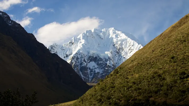
Photo: Lidsay Brito, CC BY-SA 4.0, cropped
The Santa Cruz Trek is the classic multi-day trek of Peru's Cordillera Blanca, the highest tropical mountain range in the world. It crosses Huascarán National Park, a UNESCO World Heritage Site, from Vaquería on the Yungay-Yanama road to the village of Cashapampa above Caraz. On the way it climbs over Punta Unión (4,750 m), a notch in the rock wall below Nevado Taulliraju, and passes turquoise lakes and some of the most famous peaks of the Andes, including Alpamayo, Artesonraju and Quitaraju. There are no huts or lodges on the trail: you camp at free designated campsites and carry, or hire donkeys to carry, all your food and gear. Most people take 4 days.
The route
The trek starts at Vaquería (about 3,700 m), a hamlet on the road over the Portachuelo de Llanganuco. The path drops to Colcabamba and climbs gently up the green Huaripampa valley, past the park control post, to the Paria campsite (3,850 m). Day 2 is the big one: a steady climb of nearly 900 m on rocky switchbacks to Punta Unión, with Taulliraju above and the Santa Cruz valley below, then a descent past Laguna Taullicocha to the Taullipampa campsite (4,250 m), the highest night. Day 3 follows the long, sandy Santa Cruz valley past Laguna Ichiccocha and Laguna Jatuncocha to Llamacorral (3,760 m). Day 4 drops through a narrow gorge to Cashapampa (2,900 m), where colectivos leave for Caraz.
This guide follows the route mapped on OpenStreetMap and splits it into 4 stages, about 11.3 km each, ending at the campsites most groups use: Paria, Taullipampa and Llamacorral. The line from Vaquería to Cashapampa is 45 km. You will see figures from 45 to 52 km: the higher numbers include the side trip to the Alpamayo base camp and Laguna Arhuaycocha (about 7 km return) and the walk from the road end at Colcabamba or Huaripampa village, and blog GPS tracks differ by a few kilometres. The trek can be walked in reverse from Cashapampa, but then day 1 climbs about 850 m and the pass day is longer.
Highlights
- Punta Unión (4,750 m): the pass, with Taulliraju close above and views down both valleys
- Alpamayo and Laguna Arhuaycocha: a side trip of 3 to 4 hours return from below Taullipampa to the base camp and the glacier lake under the south face of Alpamayo, called "the most beautiful mountain in the world" since the 1960s
- Taullipampa: a high meadow camp below the icefalls of Taulliraju
- Ichiccocha and Jatuncocha: two long blue-green lakes in the Santa Cruz valley, with Artesonraju behind
- The Santa Cruz gorge: a steep, narrow canyon with waterfalls on the last morning
When to go
The dry season, May to September, is the time to go; SERNANP recommends May to October. June to August have the most stable weather and the busiest campsites. Days are sunny and warm, but nights at Taullipampa often fall below freezing. The rainy season runs from October to April: expect afternoon storms, snow on Punta Unión, mud and cloud over the peaks.
How many days do you need?
Most people take 4 days and 3 nights. Fast walkers do it in 3 days by camping at Taullipampa and Llamacorral only. Add a day if you want to camp at the Alpamayo base camp. Before the trek, spend at least 2 or 3 nights in Huaraz (3,050 m) and do a day hike such as Laguna Churup or Laguna Wilcacocha to acclimatise.
Permits, fees and guides
Every visitor needs a Huascarán National Park ticket, checked at two control points: the Huaripampa post on the Vaquería side and the ranger post at Cashapampa. In 2026 a foreign visitor pays S/60 for 2 to 3 days or S/150 for 4 to 30 days; a 4-day trek formally needs the S/150 ticket. Buy it online on the SERNANP ticket site, at the park office in Huaraz (Jr. Federico Sal y Rosas 555) or at the control posts, in cash soles, and carry your passport.
A guide is not mandatory on the Santa Cruz trek. Since February 2026, however, Laguna 69 and Nevado Pisco can only be visited through SERNANP-authorised agencies, and the SERNANP visitor portal says park visits should use authorised operators. Check at the park office in Huaraz before you go independently. Most trekkers book a group tour in Huaraz that includes transport, a guide, a cook and donkeys (arrieros); the park ticket is usually extra.
Getting there and away
Huaraz is about 8 hours by bus from Lima. To reach Vaquería, take a colectivo from Huaraz to Yungay (about 1 hour), then a minivan towards Yanama over the Portachuelo de Llanganuco (4,767 m) and get off at Vaquería (2.5 to 3 hours); leave Huaraz by 6 am. From Cashapampa, colectivos run to Caraz (about 1 hour, about S/10), and buses go on to Huaraz (about 2 hours). Small guest houses at Vaquería and Cashapampa help if you arrive late.
Money, food and phone signal
There are no shops, ATMs or lodges on the trail. Bring cash soles from Huaraz or Caraz for the park ticket, transport and the occasional snack sold at Llamacorral in high season. There is little or no mobile signal for most of the trek, so carry an offline map and, ideally, a satellite messenger.
What to pack
A tent that can take wind and frost, a sleeping bag rated to about -10 °C, a stove and fuel (campfires are banned), food for 4 days, a water filter or tablets (cattle graze in every valley), warm layers, a hat and gloves, waterproofs, sunglasses and strong sun cream, and insect repellent for the sandflies below 4,000 m. Buy gas canisters and hire gear in Huaraz.
Difficulty and safety
The Santa Cruz Trek is a moderate to hard high-altitude trek. The path is clear and well used, but you walk between 3,500 and 4,750 m for three days, and the climb to Punta Unión is steep and loose near the top. Altitude sickness is the main risk: acclimatise in Huaraz first, walk slowly, drink plenty and go down if headache, vomiting or confusion get worse. In an emergency call 105 (police) and ask for the high-mountain rescue unit (USAM), or 106 for an ambulance; an injured trekker usually has to be carried out by horse to Vaquería or Cashapampa. Give way to donkeys and cattle on the uphill side of the path, keep food in your tent, and do not leave the marked trail after Punta Unión.
History
The Cordillera Blanca has been farmed and grazed by Quechua communities for centuries, and the trek still passes their herds and stone corrals. Huascarán National Park was created in 1975 to protect the range's glaciers and lakes, and it became a UNESCO World Heritage Site in 1985. The route over Punta Unión became popular with climbers heading to Alpamayo, and today it is the most walked multi-day trek in the Cordillera Blanca.
Santa Cruz Trek map
The whole Santa Cruz Trek with its 4 stages, Vaquería to Cashapampa. Tap a stage on the map to open it. To follow the route with GPS and offline maps on the trail, open it in the free Outest app.
The 4 stages
The classic four days from Vaquería on the Yungay-Yanama road over Punta Unión (4,750 m) to Cashapampa above Caraz, camping at Paria, Taullipampa and Llamacorral. Walking times allow for the altitude and a full pack; the side trip to the Alpamayo base camp and Laguna Arhuaycocha (3-4 hours return) is extra. Each stage page has a map, elevation profile, the campsites and the nearest help.
| # | Stage | Distance | Level |
|---|---|---|---|
| 1 | Vaquería → Paria | 10.2 km | moderate |
| 2 | Paria → Taullipampa | 11.6 km | hard |
| 3 | Taullipampa → Llamacorral | 13.6 km | moderate |
| 4 | Llamacorral → Cashapampa | 9.8 km | moderate |
Emergency, hospitals and services
In an emergency call 105 (police) and ask for the high-mountain rescue unit USAM, or 106 for an ambulance. There is little or no phone signal on the trek, so carry a satellite messenger. 4 hospitals with an emergency service are within reach by road, in Yungay, Caraz and Huaraz; an injured trekker usually has to be carried out by horse to Vaquería or Cashapampa first. Every stage page lists the nearest help.
Where to stay on the Santa Cruz Trek
Free designated campsites on the trail and the guest houses and hotels at both ends, grouped by stage from Vaquería to Cashapampa. Listings were checked online in October 2026. Places marked "not confirmed by the operator" are listed on OpenStreetMap, booking sites or in trekking guides but could not be checked on an official page. The campsites cannot be booked, so carry a tent; book rooms in Huaraz and Caraz ahead in June to August.
Vaquería (trailhead)
6 places
- 6 with rooms
- 2 camping
- 5 with meals
Colcabamba · Huaraz · Vaquería
Vaquería → Paria
2 places
- 2 camping
Huaripampa · Paria
Paria → Taullipampa
1 place
- 1 camping
Taullipampa
Taullipampa → Llamacorral
3 places
- 3 camping
Arhuaycocha · Jatuncocha · Llamacorral
Llamacorral → Cashapampa
6 places
- 6 with rooms
- 4 with meals
Caraz · Cashapampa · Conay · Santa Cruz de Huaylas
Plan your days
Pick any Santa Cruz Trek stage in the free hike planner to see walking time, water to carry, calories, difficulty, the weather forecast and daylight.
More trail guides

Inca Trail
Peru · Cusco · 34 km · 4 stages
Salkantay Trek
Peru · Cusco · 65 km · 4 stages

Huayhuash Circuit
Peru · Áncash · 96 km · 9 stages

Choquequirao Trek
Peru · Apurímac and Cusco · 30 km · 3 stages

Tour du Mont Blanc
France · Italy · Switzerland · 166 km · 11 stages

Alta Via 1
Italy · Dolomites · 118 km · 11 stages
GR 20 · John Muir Trail · Laugavegur · Cotswold Way · Kerry Way · Camino Finisterre · West Highland Way · Walker's Haute Route · Kungsleden · Tour of Monte Rosa · Coast to Coast Walk · Pembrokeshire Coast Path · Hadrian's Wall Path · South Downs Way · Dingle Way · Wicklow Way · Fishermen's Trail · Camino Portugués · Alta Via 2 · Malerweg · Peaks of the Balkans · Overland Track · Lycian Way · St Paul Trail · Camino Francés · W Trek · Everest Base Camp Trek · Annapurna Circuit · Kumano Kodo Nakahechi · Camino del Norte · Via Francigena · GR10 · Pennine Way · Carian Trail · Evliya Çelebi Way · Kaçkar Mountains Traverse · Phrygian Way · Sultans Trail · Mount Ararat Climb · Hittite Trail · Troy Culture Route · Independence Way · Mysia Ways · Rheinsteig · Westweg · Goldsteig · GR54 Tour des Écrins · Via Alpina · Path of the Gods · Cinque Terre Trail · Alta Via 4 · GR221 Dry Stone Route · Stubai High Trail · Milford Track · Routeburn Track · Kepler Track · Tongariro Northern Circuit · Larapinta Trail · Great Ocean Walk · West Coast Trail · Wonderland Trail · Teton Crest Trail · Annapurna Base Camp Trek · Markha Valley Trek · Kilimanjaro Machame Route · Toubkal Circuit · Jordan Trail: Dana to Petra · Torres del Paine O Circuit · Abel Tasman Coast Track · Three Capes Track · Mestia to Ushguli Trek · Nakasendo Way · Berg Lake Trail · Skyline Trail (Jasper) · Fitz Roy & Cerro Torre Loop · Otter Trail · Fish River Canyon Hiking Trail · Camino Primitivo · Camino Inglés · Eagle Walk (Adlerweg) · Berliner Höhenweg · Cape Wrath Trail · Great Glen Way · Offa's Dyke Path · Cleveland Way · Rota Vicentina Historical Way · Via Podiensis (GR 65) · Heaphy Track · Queen Charlotte Track · Cape to Cape Track · Rockwall Trail · Juan de Fuca Marine Trail · Quilotoa Loop · Nahuel Huapi Traverse · Ala Kul Trek · Tiger Leaping Gorge High Trail · Mount Kenya Sirimon–Chogoria Traverse · Ghorepani Poon Hill Trek · Kilimanjaro Lemosho Route · Lebanon Mountain Trail · Aladağlar Traverse · Kokoda Track · Chilkoot Trail · Lost City Trek · GR R2 Réunion · M'Goun Traverse
Hike it with the route in your pocket
Outest has the Santa Cruz Trek route offline, with elevation, water and village points, and a trail guide you can ask about stages, weather and where to sleep.